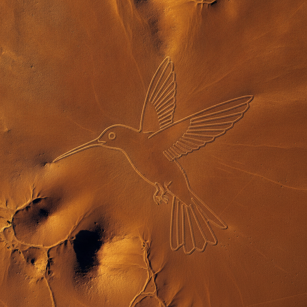
The Nazca Lines: A Message Written in the Desert — But for Whom?
From the ground, the Nazca pampa is one of the emptiest places on earth: a reddish-brown plain of stone and grit stretching between the Andean foothills and the Peruvian coast, where it almost never rains and almost nothing grows. Rise a few hundred meters into the air, though, and the desert floor turns into a canvas.
A hummingbird with a wingspan of nearly a hundred meters. A monkey with a tail that coils into a perfect spiral. A spider, a condor, a pelican, a whale, and dead-straight lines that run for kilometers across the plateau as though drawn with a ruler and never allowed to waver. There are more than a thousand of these figures and lines, known as geoglyphs, scratched into the earth between roughly 500 BC and 500 AD, most of them the work of the Nasca culture that flourished here long before the Inca.
How they were made is not, in truth, much of a mystery. The surface of the pampa is littered with dark stones, coated over millennia by a thin varnish of iron oxide. Sweep them aside and the pale yellow ground beneath shows through as a bright line. With nothing more than wooden stakes, lengths of cord and careful sighting by eye, small teams could lay out even the largest figures, and archaeologists have reproduced the technique in the field.
The desert did the rest. Because this is one of the driest and least windy places on the planet, the shallow furrows, some only a few centimeters deep, have survived two thousand years almost untouched. There is no vegetation to grow over them, almost no rain to wash them out and little wind to fill them in.
The lines were first noted from the surrounding foothills by the Peruvian archaeologist Toribio Mejia Xesspe in 1926. It was the arrival of commercial aircraft in the 1930s, and passengers gazing down at the desert on the run between Lima and the south, that revealed the full menagerie and turned Nazca into a puzzle for the world.
The scale is hard to grasp even in numbers. The geoglyphs are spread across a protected desert zone of hundreds of square kilometers. Some of the straight lines run arrow-true for several kilometers, climbing low ridges and dropping into shallow valleys without so much as a bend, while the figures range from a few dozen meters to nearly the length of three soccer fields.
The wonder is not only that people made them, but that they made them without ever once seeing the finished shape. Every curve was plotted on the ground by measurement, cord and memory alone, by crews who could not step back far enough to check their work.
The person who did most to record them was Maria Reiche, a German-born mathematician who settled in Peru, mapped the figures obsessively over decades, swept the desert with a broom to keep them clear, paid out of her own pocket for guards, and lived beside the pampa until her death in 1998. She warned, long before anyone else did, that a single careless boot or tire could scar a line that had lasted two thousand years.
She was right to worry. The Pan-American Highway was driven straight across the pampa in the twentieth century, slicing through one of the figures. Careless drivers have left tire tracks that will take ages to fade. In December 2014 activists from Greenpeace walked into the restricted zone beside the hummingbird to lay out a protest message, leaving footprints in ground so delicate that Peru pressed criminal charges over the damage. What took the Nasca generations to trace can be scarred in a single afternoon.
The record is still growing. In September 2024 a team led by Masato Sakai of Japan's Yamagata University, working with IBM Research, published a study in the Proceedings of the National Academy of Sciences describing 303 previously unknown figurative geoglyphs. They were found in barely six months, after an artificial-intelligence system scanned vast quantities of aerial imagery and flagged the most promising spots for archaeologists to check on foot. The discovery nearly doubled the number of known figurative designs at a stroke.
It also revealed a pattern. Many of the newly found figures are smaller relief-type geoglyphs, made by piling stones rather than clearing long lines. They cluster beside ancient footpaths and depict humans and domesticated animals, at a size that suits close viewing by individual travelers passing on foot. The huge line-type figures, by contrast, sit nearer the broad ceremonial routes that cross the plateau.
So the basic facts are settled. We know who made the lines, roughly when, with what tools, and on what surface. We know they were made over a span of about a thousand years, by more than one generation and in more than one style. We can now watch an algorithm find more of them faster than any human eye. What no excavation, no survey and no computer has yet delivered is a reason.
Conclusions and Open Questions
Five explanations have dominated a century of argument, and each of them leaves something out.
The astronomical calendar theory began with the American scholar Paul Kosok, who flew over the lines in 1941 and, watching the sun set along one of them near the winter solstice, called the pampa the largest astronomy book in the world. Maria Reiche defended and elaborated it for the rest of her life, arguing that the orientations marked solstices, the rising of certain stars and the turning of the seasons that told the Nasca when to plant. Its weakness is statistical. In the late 1960s the astronomer Gerald Hawkins fed the orientations of 186 Nazca lines into a computer and compared them with the positions of the sun, moon and bright stars across the centuries. Only about a fifth lined up with anything in the sky, no more than chance would predict. Two decades later the archaeoastronomer Anthony Aveni reached much the same conclusion.
The water and fertility ritual theory was proposed in 1985 by the anthropologist Johan Reinhard, who argued that the great trapezoids and triangles were cleared spaces where people gathered, walked and danced to petition the mountain gods, the apus, believed to control the water on which all life here depended. In this reading the hummingbird, spider and monkey are not portraits but symbols of water and fecundity in Andean thought. Its weakness is that it explains the cleared spaces far better than the animals, and cannot say why these particular creatures were chosen or why the styles change over time.
A related idea, argued by the researcher David Johnson and others, ties the lines physically to water. The Nasca endured in this desert partly through puquios, spiraling wells and underground channels that tapped hidden aquifers, and Johnson suggested that some straight lines and triangles trace the courses of those subterranean waters. Its weakness is coverage: even if some lines mark water, no single water theory accounts for every figure scattered across the plateau.
The processional pathway theory rests on the plainest evidence of all. Many geoglyphs form single unbroken paths that loop through a whole figure and out the other side, so that a procession could enter at the beak of the hummingbird, trace its entire body and leave without ever crossing its own trail. Aveni and others have argued that the geoglyphs were ritual routes connecting sacred points across the desert. Its weakness is that it describes what people did with the lines rather than why they cut them in those particular shapes.
Then there is the theory that made Nazca famous far beyond archaeology. In his 1968 bestseller Chariots of the Gods, the Swiss writer Erich von Daniken claimed the long, wide trapezoids were runways for ancient astronauts and the figures signals to beings in the sky. Archaeologists reject this claim, and the evidence is against it. The Nasca demonstrably had the tools, the technique and the reasons to make the lines themselves; a soft desert surface makes an absurd runway, and the assumption that ancient Peruvians could not have created such art without outside help says more about the 1960s than about the pampa.
What remains genuinely unexplained is narrower, and more interesting. Why invest generations of labor in images so large that no one on the ground can take them in whole? Many geoglyphs can be glimpsed from the surrounding foothills, but not all of them and not fully. Why do the styles differ so sharply between eras? A thousand years is longer than separates us from the Norman conquest of England, and it may be a mistake to assume that all these marks were made for one reason at all.
The 2024 pattern points that way. One theory holds that Nazca is not one message but many, made by different hands over many centuries for different audiences: small relief figures for the traveler on the path, vast line figures for the ceremonial route. Some argue further that for the people who made them the act of making, the collective labor of walking a line into the desert as an offering, mattered more than any finished picture seen from above. If that is right, the question we keep asking, who were the lines meant to be seen by, quietly assumes the very thing that is not true.
The open questions are concrete. Can the newly found relief geoglyphs be dated closely enough to sort the styles into a real sequence? Do the footpath figures correlate with settlements, water sources or both? Will the same AI survey method, applied to the rest of the pampa, keep multiplying the count until the word mystery no longer fits? Two thousand years on, no one can say with certainty what the people of Nasca were trying to say, or to whom: the gods on the mountains, the water beneath the sand, the travelers on the path, or simply one another.